|
PHASE I & II ENVIRONMENTAL SITE ASSESSMENTS
|
|
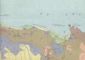
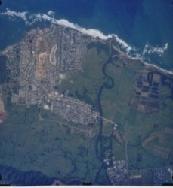
GeoEnviroTech is on the leading edge in conducting Phase I Environmental Site Assessments (ESA) following the current ASTM Standard E-1527. We provide the most accurate information and the latest integration of digital information, including digital maps, aerial photographs, governmental agencies and data search. All this data is complemented with site inspections and digital photographs of the site.
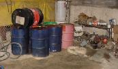
In conducting Phase II ESA, our firm follows the current ASTM Standard Guide E-1903. A Phase II ESA is conducted to corroborate the Recognized Environmental Conditions identified in the Phase I ESA process for the purpose of providing sufficient information regarding the presence or absence of contamination to assist in making informed business decisions about the property and plan for additional studies and remediation alternatives. Our personnel have experience in performing complicated assessments to different kind of properties. We use the latest in computer imaging and modeling, databases search, digital photos and maps.
GeoEnviroTech, Inc. uses ESRI’s ARCView® software (GIS) to manage data and create reports with varying levels of information to better make technical and managerial decisions. Information is geocoded to conform to Puerto Rico.
| |
|
|